Note the "Welcome" sign and natural vista reminiscent of Edward Abbey's days
White sandstone pillars of "Capitol Reef"
Hoodoos of Capitol Reef NP
Pre-National Park, it's no wonder that Native Fremont Indians called this vast landscape of tilted buttes, jumbled rocks and winding canyons the "Land of the Sleeping Rainbows".
Aside from the widely-varied rock and canyon formations all carved by water, a very unique aspect of Capitol Reef National Park is the "town" that lies in the heart of the Park--the Fruta Historic District--a cool green oasis where mature, shade-giving cottonwoods and fruit-bearing trees line the banks of the Fremont River. Providing fruit and nuts for subsistence, trade, and sale, the first Mormon homesteaders arrived in 1880 and Fruta's final resident left in 1969. The National Park Service now maintains the 2,700 cherry, apricot, peach, pear and apple trees planted by early settlers, and if you visit between June and October, you can eat ripe fruit straight from the trees for free!
Overlooking the orchards of Fruta Historic District from Chimney Rock Trail
A funny side observation during our visit here, being outdoors, most visitors/hikers were sans masks (us included), but every once and a while we encountered the "glares" of masked marauders who couldn't pass by us fast enough! Hilariously, they would grab their masks from around their necks and pull them up over their mouths as if perhaps we might aim and perfectly fire a spitball at them as they passed. We quickly noted that nearly all those folks were aged 20-30 and they were from California, Colorado, or Oregon...we tracked the license plates in the parking lots 

After Torrey we headed south to Escalante, Utah (through Flaming Gorge) to take in the immensity and beauty of Grand Staircase Escalante National Monument (GSENM). Established in 1996 as the Bureau of Land Management's first national monument, GSENM doesn't really have an "entrance" but is a compilation of three distinct topographies comprising 1.9M acres of protected land: the Grand Staircase, the Kaiparowits Plateau, and the canyons of the Escalante River. What these three areas share are great distances, expansive vistas, primitive and difficult terrain, and a remoteness rarely equaled in the lower 48 states; they also hold a special place in the soul of pioneers, explorers and Native Americans. This was evident even at our camping spot on public land off of the Hole-in-the-Rock Road--made famous by the Mormon pioneers.

GSENM encompasses challenge, untrammeled beauty, and the frontier spirit and we were aptly rewarded with stunning hikes through magnificent river washes, multicolored plateaus and terraces, as well as intrepid slot canyons during our visit.
One of our favorite hikes by far (i.e., if you visit here, you MUST take this hike!) was to Lower Calf Creek Falls, a moderate 6-mile roundtrip hike worth every footstep!!
Just another hike in the Utah Canyonlands Desert...
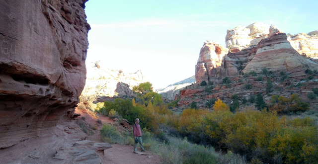
...but note the cottonwoods at the foot of those spires...
...and the Ancient Puebloan granaries for storing corn, grain, and other foods harvested nearby...
...and the abundant trout in Calf Creek's natural "ponds"...
This is NOT just another Utah desert hike...Look Up!!
Named for its use as a natural pen for calves in the late 1800's, Calf Creek was relatively unknown until the formation of GSENM. Walking between mineral-streaked cliffs of Navajo Sandstone, we passed beaver ponds. trout pools, and pre-historic rock art sites ending at this perennial 126-foot cascading waterfall and its paradisaical pools--truly a verdant desert oasis!
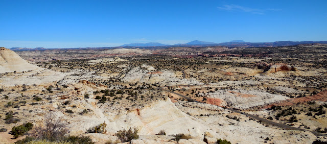
One of the most notable "historical" attraction of GSENM, is the 57-mile long Hole-in-the-Rock Scenic Backway--a gravel and dirt road that closely follows the wagon route taken by Mormon pioneers in 1879-80 in an attempt to establish a shortcut across the Colorado River between established communities in the center of the state and the Four Corners area. The road was so wash-boarded that we didn't make it all the way to the Hole in the Rock on the Colorado River, but we did take enjoy hikes right off the road that gave us sense of what the Mormon pioneers would have encountered on their adventure.


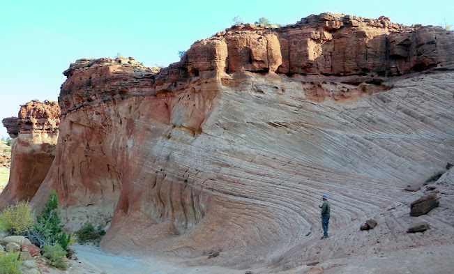
The Mormon pioneers spent nearly two months on their journey to the Colorado River. Dance and music were an important part of their society and the excellent acoustics of the natural sandstone amphitheaters they found along the way, provided perfect locations to stop and enjoy relaxing entertainment breaks in their otherwise arduous journey. These amphitheaters became known as "Dance Hall Rocks" and were welcome respites for the weary pioneers.
We chuckled at our concern over the teeth-rattling drive when we learned the history of the great Mormon expedition--
On January 26, 1880, after six months of blasting and chiseling, an expedition of 250 Mormon Pioneers with their wagons and livestock descended through a rocky crevice known as the Hole in the Rock to the Colorado River below (now Lake Powell). The 1,300 foot descent approaching 45 degrees could only be accomplished after widening the upper section with blasting powder, chiseling off high points in the dugway, creating anchor points directly into the sandstone for large ropes to hold back the wagons, and with pick and shovel building up a road bed at key points.While the Hole in the Rock was a major obstacle, the overall journey from Escalante to Bluff, Utah was nearly 200 miles of the most forbidding area to travel.
___________________________________________________________________________
As if to make a point, though, we encountered some "pioneer" experiences with our RV at this point in our travels. Given that GSENM is comprised of nearly 2M acres of protected land, cities and towns are few and far between and those that are nearby are not bustling with commercial activity so resources are limited. First, we had a water valve break in our basement. Fortunately, the water pump was off so the resulting basement "flood" was not so bad, but without a valve replacement, we were unable to use any faucets in our RV. Water was free and plentiful at the national monument headquarters so we just filled any and all available water carriers to use in the RV and heated water in pots for washing and showers.
But then one day we noticed that we no longer had AC power in our RV--the DC power from the solar was working fine, but the inverter was not producing AC power for the electrical outlets. Again, not a big deal, but we had limited comfort in not being able to charge our computers or MiFi for communication purposes. Usually when we're on the road we visit local coffee shops, etc., to get on our computers and keep them charged, but during this age of Covid, the businesses that we would rely on for this service were either closed or open for take-out only...and electricity wasn't on the take-out menus!
We thought about shortening our visit to the area, but the weather continued to be so amazing and the hiking and sightseeing so exceptional, that we decided to "pioneer" it. Okay, I suppose running the truck engine to charge our computers/MiFi isn't really "roughing" it, but without running water and electricity in our RV, we did kind of feel like we were telepathing those Mormon pioneers 
____________________________________________________________________________
After Escalante, we drove directly "through" Bryce Canyon National Park, and honestly, we didn't even feel like we missed out by not paying the $50(!) entrance fee. The iconic crimson-colored hoodoos were EVERYWHERE!! In fact, some of the best photos I took were from the truck window as we wound our way through the spire-constrained single-lane highway...with rig in tow!! Talk about adventure!!


No comments:
Post a Comment